
The 2026 El Niño, confirmed to begin in May, is predicted to increase super typhoons and flooding risks in China, as illustrated by Super Typhoon Sinlaku’s unprecedented strength. This climate pattern shifts ocean energies and weather dynamics, endangering young people with severe weather extremes throughout the year, necessitating safety preparations.
Imagine a typhoon in April—usually a quiet month for Western Pacific tropical cyclones—with sustained winds exceeding 70 meters per second, strong enough to cause near-catastrophic damage on Saipan and leave a 920 hPa pressure reading even after dramatic weakening. This is Super Typhoon Sinlaku, the strongest April typhoon in the satellite era, surpassing 2021’s Typhoon Surigae. For young people across China, this extreme storm is not just a viral weather headline—it’s the first clear warning of a confirmed, game-changing climate shift: the 2026 El Niño is officially on the way, and it will reshape China’s weather for the rest of the year.
The 2026 El Niño: It’s Officially Locked In
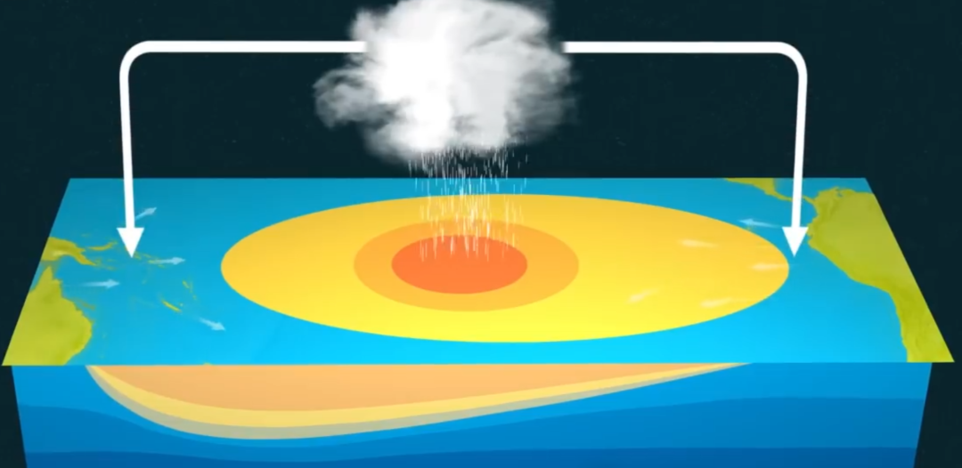
First, let’s break down what El Niño actually is, in simple terms. El Niño is a natural climate pattern marked by abnormal warming of surface waters in the equatorial central and eastern Pacific Ocean. It is one of the most powerful drivers of global weather extremes, and for 2026, its arrival is no longer a prediction—it’s a certainty.
According to the latest official forecast from China’s National Climate Center, the equatorial central and eastern Pacific will enter El Niño conditions in May 2026, with at least a moderate-intensity event expected by winter. Early model projections that hinted at a “140-year strongest El Niño” have since been adjusted, with forecasters now predicting a peak sea surface temperature anomaly of 2.0–2.5℃. There is a 25% chance of a strong El Niño and a 20% chance of a super El Niño event by the end of the year.
Even before the official El Niño onset, the warming trend in the equatorial Pacific has already left its mark on the atmosphere—with Super Typhoon Sinlaku as the first, dramatic result.
How El Niño Fuels More, Stronger Super Typhoons
To understand why Sinlaku was so extreme, and why 2026 will almost certainly see more super typhoons, we need to look at the two key ways El Niño reshapes Western Pacific typhoon activity.
First, it supercharges ocean energy supplies for typhoons. Typhoons need warm ocean water (at least 26.5℃) to form and strengthen. In an El Niño year, the Pacific’s warm water pool shifts eastward, creating a vast area of warm water across the open Western Pacific. Critically, this warmth isn’t just skin deep: for Sinlaku, even 50 meters below the ocean surface, water temperatures held steady at 28℃, giving the storm an endless supply of fuel to intensify. Global warming amplifies this effect, as the world’s oceans have absorbed 90% of excess heat from climate change, creating a deeper warm layer that can sustain stronger typhoons for longer.
Second, it rewrites typhoon formation patterns via the Walker Circulation. The Walker Circulation is a planet-wide loop of air flow along the equator. In an El Niño year, this circulation shifts: sinking air dominates over the Philippines and Indonesia (suppressing typhoon formation close to China), while rising air fuels storm development far out in the open Pacific. This means typhoons form much farther east than usual, giving them weeks of travel over warm water to absorb energy and grow into super typhoons, rather than making landfall early.
This is exactly what happened with Sinlaku, which formed deep in the Pacific and grew into a monster storm before approaching land. Historical data backs this pattern: the 1997 super El Niño year spawned 10 super typhoons in the Western Pacific, including the massive 9711 Typhoon Winnie, one of the largest-circulation typhoons on record to hit China. The 2015–2016 super El Niño brought destructive super typhoons like Soudelor, Nepartak and Meranti, while even moderate El Niño years in 2018 and 2023 saw Super Typhoons Mangkhut, Doksuri and Haikui inflict severe damage on China.
Crucially, the old “protective” effects of El Niño for China are breaking down. Historically, El Niño years brought fewer total typhoons and made landfall in China less likely. But in recent years, this rule has collapsed: 2015 saw 27 typhoons, 2016 had 26, and 2018 recorded 29, with multiple strong and super typhoons making landfall. Even typhoons forming 6,000 km off China’s coast, like Mangkhut, can maintain their strength through the long journey and hit the Pearl River Delta with devastating force. For 2026, this means a higher-than-normal chance of super typhoons reaching China’s coasts starting as early as May.
Beyond Typhoons: El Niño’s Full Impacts on China
Typhoons are the most immediate impact of the 2026 El Niño, but they are far from the only one. This climate pattern will reshape China’s weather across the entire year, with two key risks for young people to watch:
- Elevated flood risk in the Yangtze River Basin: El Niño is historically linked to severe flooding in China’s Yangtze River Basin. Most infamously, the 1998 super El Niño triggered a catastrophic basin-wide flood that affected 230 million people. In El Niño years, summer monsoon rain bands tend to stall over the Yangtze River and southern China, bringing prolonged, heavy rainfall and a high risk of both river flooding and urban waterlogging.
- Shifting temperature and rainfall patterns: El Niño typically brings a warmer winter to most of China, with weaker cold air outbreaks. For summer, it often drives a “south flood, north drought” pattern, with above-average rainfall in the Yangtze and southern China, and an increased risk of heatwaves and drought in northern provinces.
Prepare for El Niño-Driven Extremes
For young people—whether you’re a student living in a coastal city, a summer traveler planning a beach trip, or living in the Yangtze River Basin—these simple, actionable steps will keep you safe through the 2026 El Niño:
- Enable real-time emergency alerts: Download the official China Meteorological Administration app, and turn on Wireless Emergency Alerts on your smartphone. These free, location-based alerts will warn you of incoming typhoons, heavy rain and floods even if your phone is on silent.
- Master typhoon safety basics: If you live in a coastal dorm or rental apartment, identify your safe spot now—an interior room with no windows, away from balconies. Stock a compact emergency kit with 3 days of bottled water, non-perishable snacks, a flashlight, a portable charger and a basic first-aid kit. Never go outside during a typhoon, even if the wind dies down temporarily.
- Avoid flood risks at all costs: Never drive, walk or swim through floodwater. Just 15 cm of fast-moving water can knock an adult off their feet, and 30 cm can sweep a car away. During heavy rain, stay away from rivers, low-lying underpasses and mountainous areas at risk of landslides.
- Travel smart this summer: If you’re planning a coastal or island trip during typhoon season (May–October), check the 7-day typhoon forecast before booking, and have a flexible backup plan. Never travel to remote islands during a typhoon warning, as you may be stranded with no way to evacuate.
El Niño in a Warming World
Super Typhoon Sinlaku and the upcoming 2026 El Niño are a stark reminder that natural climate patterns and human-caused global warming are now working in tandem to create more extreme weather. El Niño is a natural cycle, but climate change is amplifying its impacts: warmer oceans fuel stronger typhoons, a more unstable atmosphere drives more intense rainfall, and long-standing climate rules are breaking down before our eyes.


Leave a Reply