
Australia’s north is in an active monsoon phase, with multiple tropical lows developing. Queensland faces cyclone alerts, 100-300mm extreme rain and flood warnings. This article breaks down the weather science, risks, and essential safety tips for young people.
If you’re planning a backpacking trip to Queensland’s Daintree Rainforest, a beach getaway to Cairns, or live in northern Australia, this unfolding weather event demands your attention. A powerful, active monsoon is gripping Australia’s north, spawning tropical low pressure systems that could strengthen into cyclones, while already dumping record-breaking rain and triggering flood alerts. For young travellers, students, and locals, understanding this weather isn’t just about science—it’s about staying safe and avoiding disrupted plans.
The Science: What’s Driving the Wild Weather?
At the heart of this event is a monsoon trough—a long stretch of low pressure that forms over northern Australia during the southern hemisphere summer and autumn. This trough is the engine of Australia’s wet season, pulling warm, moist air from the Coral Sea and Arafura Sea, and fuelling heavy rain, thunderstorms, and the development of tropical lows.
As the Bureau of Meteorology (BOM) senior meteorologist Jonathan Howe explains, northern Australia is now in a clear, active monsoon phase. This phase is pumping widespread showers and rainfall across the entire top end of the country, with the heaviest falls focused on northeast Queensland.
For a tropical low to grow into a named tropical cyclone, it needs three key things: warm ocean waters (at least 26.5°C), low wind shear (so the storm structure doesn’t get torn apart), and the spin of the Earth’s Coriolis effect. Right now, the waters off Queensland’s coast are warm enough to support cyclone development, which is why BOM is closely watching two key systems.
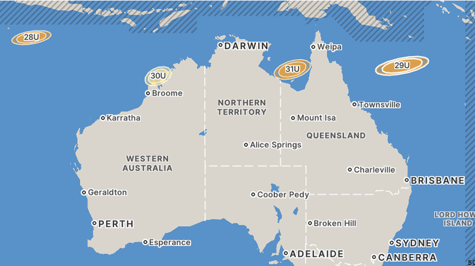
The Two Key Weather Systems We’re Tracking
Two tropical lows are the main focus for forecasters, each with different risks and development potential:
- Tropical Low 29U (Coral Sea)This system is the biggest cyclone threat. Sitting over the Coral Sea as of early March, BOM gives it a 25% chance of strengthening into a tropical cyclone from Wednesday onward. Forecasts show it is increasingly likely to approach Queensland’s northeast coast, with a potential landfall between Cairns and Mackay later in the week. Even if it doesn’t reach cyclone strength, it will dump heavy rain along the coast as it moves closer to land.
- Tropical Low 31U (Gulf of Carpentaria)This second system formed over the Gulf of Carpentaria, with a lower 10-15% chance of developing into a tropical cyclone. It is forecast to track west into the Northern Territory, bringing widespread rain and thunderstorms to the Gulf Country and northern inland regions, rather than cyclone-strength winds.
Crucially, even if neither system becomes a named cyclone, the combination of the monsoon trough and multiple tropical lows will still unleash days of heavy rain and storms across northern Australia. Weatherzone meteorologist Ben Domensino notes that some computer models show the eastern low could even push heavy rain into central and southeast Queensland by the weekend, extending the risk far beyond the tropical coast.
The Immediate Risk: Extreme Rain and Devastating Floods
The rain has already arrived, and the flood risk is very real. In just one night, northeast Queensland’s tropical coast saw 100mm to 300mm of rainfall—enough to send rivers rising rapidly. BOM has issued a major flood warning for the Herbert River, and a minor flood alert for the Daintree River, two iconic waterways popular with tourists and locals alike.
Even without cyclone-force winds, this extreme rainfall brings the most immediate danger. Flash flooding can turn quiet creeks into raging torrents in minutes, close roads, cut off remote communities, and trap travellers. Coastal areas also face risks of dangerous surf, large waves, and coastal inundation if the systems track close to shore.
For context, this is all unfolding during Australia’s official tropical cyclone season, which runs from November to April each year. So far this season, 9 tropical cyclones have formed in the Australian region. If any of the current lows strengthen into a named cyclone, the next four names in line are Narelle, Oran, Peta, and Riordan.
Youth Safety Guide
Whether you’re a local student, a backpacker travelling the east coast, or living in a regional town, these simple, actionable steps will keep you safe:
- Follow official alerts first: Download the BOM Weather app and your state’s emergency alert app (e.g., QLD Alert) for real-time warnings. Social media updates are no replacement for official, verified flood and cyclone alerts.
- Never drive, walk, or swim through floodwaters: It takes just 15cm of moving water to knock over an adult, and 30cm to sweep a car away. This is the leading cause of death in Australian flood events—don’t risk it, even for a short trip.
- Pack a compact emergency kit: For your apartment, share house, or travel bag, keep non-perishable snacks, bottled water, a flashlight, a portable phone charger, and a first-aid kit. Power outages are common in heavy rain and wind events.
- Adjust travel plans early: If you’re planning a trip to far north Queensland, check road closures with Queensland Transport, confirm bookings with accommodation providers, and have a backup plan if flights or tours are cancelled.
- Check in on others: Reach out to friends, roommates, or fellow travellers who might be in remote areas or less familiar with Australian flood and cyclone risks. Community care makes a huge difference in emergencies.
Climate Change and Australia’s Extreme Wet Season
This active monsoon and cyclone risk isn’t happening in a vacuum. Climate scientists have long warned that global warming is amplifying the risks of extreme weather in Australia, even as the total number of tropical cyclones in the Australian region may decrease.
The IPCC’s Sixth Assessment Report confirms that tropical cyclones are likely to bring more intense rainfall and higher wind speeds in a warmer world. Warmer oceans hold more moisture, which means even if a low doesn’t become a cyclone, it can dump far more rain than similar systems did decades ago—driving more frequent and severe flash flooding.
For young people in Australia, this event is a reminder that extreme weather is no longer a rare event. Understanding the science, being prepared, and taking warnings seriously are the best tools we have to stay safe, whether we’re at home or on the road.


Leave a Reply